Cemeteries in the Snowy Monaro Region

Example-of-Cooma-Lawn-Cemetery-Headstone.jpeg

For information about the cemeteries within the Snowy Monaro Region please choose the cemetery from the list below.

It should be noted that there are cemeteries within the region that are privately owned or owned by Churches and not under the care and control of Council. Information on some of these cemeteries may still appear in this list.


Adaminaby Cemetery

Adaminaby Cemetery.jpeg

Adaminaby Cemetery is approximately 2 kilometres from the town of Adaminaby at the intersection of the Snowy Mountains highway and Yens Bay Rd.

In 1949 work began on the Snowy Mountains Hydro Electric scheme and part of the plan was for the newly formed Lake Eucumbene to cover the old township of Adaminaby. A site some kilometres east of the old town was laid out for the new town.

A survey plan for the new cemetery was prepared in 1960 after the flooding by the Snowy Mountains Hydro Electric Scheme of Old Adaminaby in 1957.

Grave sites at the cemetery can be single of double depth and they can be pre purchased from Council. The denominational sections of the cemetery are Catholic, Independent, Anglican and Presbyterian.

There is also a columbarium which provides niches for the placement of ashes, these niches can also be pre purchased. Plaques can be purchased through a monumental mason. Ashes can be placed in an existing grave providing details of the deceased are given to Council so we can maintain our records.

Details of the deceased must be given to Council for the maintenance and upkeep of our register.

Right of Burials and Placement of Ashes applications forms are available from council.


Aston Cemetery

Historical Burial Site

Located about 12 km west of Bombala, by the road to Delegate is the Aston Burial ground.

It was created in 1845 as a gift of "one acre" to the family of David McKeachie by his employer James Matheson the then owner of Aston.

Photos and history can be viewed here.


Bibbenluke Cemetery

Located on Moore Springs Road, Bibbenluke.

This burial ground stands on private property just west of the village of Bibbenluke


Boloco Cemetery

Boloco Cemetery1.jpeg Boloco Cemetery2.jpeg

 The cemetery is located 10 kilometres south west of Dalgety on the Snowy River Way. The cemetery is directly across form St James Anglican church which was built in 1871.

The Cemetery is not divided into religious sections however there are three general sections; A, B and D.

There is no columbarium at Boloco Cemetery; ashes can be interred in an existing grave site.

Details of the deceased must be given to Council for the maintenance and upkeep of our register.

Right of Burials and Placement of Ashes applications forms are available from council.


Bombala Cemetery

The general cemetery is on the southern edge of the town, east of the Monaro Highway.


Bredbo Cemetery

Bredbo Cemetery is located on the outskirts of the town approx. 1 km from the Monaro Highway.

The cemetery serves the small village of Bredbo.

The earliest burial recorded is 1897, however there may be earlier burials as the village was established in 1836 as a stopover for travellers.


Bungarby Cemetery

Bungarby is a settlement about 36km south east of Dalgety.

There is a small cemetery which is accessed via a right of way through private property.

This cemetery is owned by the Anglican Church Property Trust of Canberra and is not under the care and control of the Snowy Monaro Regional Council.


For further information provided by Monaro Pioneers please click here


Cathcart Cemetery

Cathcart is a village 15km north east of Bombala. The general cemetery is situated 1km north of the village, opposite the old burial ground, near the racecourse.


Cooma Cemetery

Cooma Cemetery is located on Mittagang Road near the Monaro High School and is the resting place of many of the Monaro’s Pioneer families.

Pioneering families located at the Cooma Cemetery:

Cosgrove – John Cosgrove  born in 1810 and arrived in the Maneroo in the early 1830’s is regarded as one of the first settlers. 

Hain – James Hain was born in 1806 arrived in the area in approx. 1852 with his family and built “The Raglan” in 1855 and went on to run general store and Royal Hotel.

Mawson – built St Pauls Church, hospital, church at Boloco, St Johns Adaminaby, extensions to the post office.

In 1931 the Southern Cloud crashed in the Toolong Range in the Southern Alps. Wreckage of this plane was not located until 26/10/1958. A memorial to the victims of the crash is located at the cemetery.

In 1949 Cooma became the head-quarters of the Snowy Mountains Scheme. During the construction of the scheme a number of workers died. Many of these workers were immigrants and did not have immediate family available to construct headstones. Therefore there were a number of graves in the district and Cooma Cemetery which were never marked. There are a number of headstones at the Cooma Cemetery which were purchased by work-mates of the deceased. 


Cemetery Layout:
Cooma Cemetery Layout.png

Corrowong Cemetery

The cemetery at Currawang (Corrowong) is beside the Roman Catholic Church of St Peter, 18 km north west of Delegate. There is no settlement as such at Currawang (Currowong), and it should be noted that the spelling of this varies. The homestead, situated nearby, is usually spelled as Corrowong.


Craigie Cemetery

This small burial ground is situated on private property on the southern side of the road, about 11 km south east of Delegate.


Delegate Cemetery

The Delegate general cemetery is situated approximately 5km east of the township on the eastern side of the Monaro Highway.


Gegedzerick Cemetery

Gedgedzerick Cemetery.jpeg 
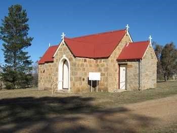
Gegedzerick Cemetery is 2 kilometres east of Berridale, a town located between Cooma and Jindabyne. The cemetery is located on the same land as St Marys Anglican Church built in 1849.

In 1827 Richard Brooks first occupied 15,000 hectares of land at Gegedzerick where he grazed cattle and sheep, the run was located northeast of Berridale. By the late 1830’s virtually the whole of the Monaro was taken up with squatting runs occupied by Europeans.

In the 1860’s the first settler was by the name of William Oliver he named his run of land ‘Berridale’ after his birth place, Berriedale, Caithness, Scotland. In 1869 the Post Office was established and Oliver built a two story granite store in 1870 which later became the Berridale Inn, his descendants still live in and around Berridale. The gravesites of these original settlers and descendants are located in the old Anglican section of the cemetery.

The denominational sections of the cemetery are Catholic, Anglican, Presbyterian, Independent and Jewish. Grave sites at the Gegedzerick cemetery can be purchased as a single depth or double depth

There is also a columbarium which provides niches for the placement of ashes. Plaques can be purchased through a monumental mason. Ashes can be placed in an existing grave site, details of the deceased must be given to Council for the maintenance and upkeep of our records.

Plots and niches can be pre purchased and a Right of Burial is issued which entitles the holder of the right to be interred in a chosen plot.

Details of the deceased must be given to Council for the maintenance and upkeep of our register.

Right of Burials and Placement of Ashes applications forms are available from council.


Jerangle Cemetery

To find Jerangle Cemetery turn into Sandy Flat Road from the Jerangle Captains Flat Road, travel 0.4km along and turn left through a gate. There is a cemetery signpost at the gate entrance. Travel 1.1 km along a dirt track and and you will come to the cemetery entrance on the ridge of a hill overlooking the the old cricket ground.

The cemetery was dedicated 24 June 1890 and was originally referred to as the General Cemetery Jinjera.


Jindabyne Cemetery

JIndabyne Cemetery.jpeg

Jindabyne Cemetery is located along the Barry Way, within the town of Jindabyne. 

The site of the old Jindabyne cemetery was flooded by the Snowy Mountains Hydro Electric Scheme when constructing Jindabyne Dam. The remains of persons buried in the Old Jindabyne cemetery were transferred to the new cemetery after the new burial ground was surveyed in 1962. 

The cemetery is sectioned into; Catholic, Anglican, Methodist, Presbyterian and Lutheran.

Ashes can be interred in an existing grave site, details of the deceased must be given to Council for the maintenance and upkeep of our register.  A columbarium is currently under construction for the placement of ashes at the cemetery

Plots can be pre purchased and a Right of Burial is issued which entitles the holder of the right to be interred in a chosen plot.

Right of Burials and Placement of Ashes applications forms are available from Council.


Michelago Cemetery

The first burial to take place was on 28 December 1860. The grave is of an unknown Irish male who died 26 December 1860 from a blow to the head.

The lower portion of the Cemetery is the Catholic Section with the Church of England section at the top. There is no clear boundary marking the areas.

The Michelago Trust have worked on identifying unmarked graves, obtaining information on deaths and placing plaques on the graves.

Buried in the cemetery in the Ryrie family plot is Major General Granville De Laune Ryrie - headstone reads that he was High Commissioner of Australia 1927-1932


Moonbah Cemetery

Moonbah Cemetery.png

Moonbah Cemetery and St Thomas’s Roman Catholic Church are situated 12 kilometres from Jindabyne along the Barry Way. Most of the graves are from the pioneering families of the area and their descendants.

Grave sites at the Moonbah cemetery can be purchased as a single depth or double depth.

Moonbah is sectioned into four general sections, A, B, C and D.

Although a columbarium is unavailable, all ashes can be interred in an existing grave site. details of the deceased must be given to Council for the maintenance and upkeep of our register.

Plots can be pre purchased and are issued a right of burial allowing the reservation of the chosen plot.


Mount Cooper Cemetery

This burial ground is on private property, approximately 1km north of the Mount Cooper homestead complex, which is located approximately 25km south of Nimmitabel.

A wall has been built at the cemetery to house all the headstones. Further information on this private cemetery can be found here.


Nimmitabel Cemetery

Nimmitabel is a small rural town on the Great Dividing Range.

The Nimmitabel Cemetery is out of the town towards Cooma along the Monaro Highway

General Maintenance of the cemetery is undertaken by a volunteer group of local residents who keep the vast area mown and tidy.


Nimmitabel Pioneer Cemetery

Nimmitabel Pioneer Cemetery has headstones which date back to 1842. This is a small plot of land down Tom Groggin Road where early settlers and surrounding areas are buried. 21 headstones remain today and there are more without headstones.


Numeralla Cemetery

Numeralla Cemetery is located approximately 3 km north of the town along Beresford Road.


Old Adaminaby Cemetery

Old Adaminaby Cemetery.jpeg

Old Adaminaby Cemetery is situated on a hill overlooking Lake Eucumbene. Access is off the Snowy Mountains highway, 10 kilometres south of Adaminaby and 8 kilometres along an unsealed road. This was the cemetery for the old township before it was flooded by the Snowy Hydro Electric Scheme.

Although the township of Old Adaminaby no longer exists, the cemetery is still open for burials.

Old Adaminaby is divided into three main sections; Catholic, Anglican and General.

It does not have a Columbarium however ashes can be interred in an existing gravesite.

Adaminaby is a result of the Kiandra gold rush in 1860, it was proclaimed a town in 1885 under the name of Seymour. The name was changed in to Adaminaby on 9th October 1886 to avoid confusion with Seymour, a town in Victoria. Prior to this time it was a cattle station ran by York and Cosgrove. The town came into being after the gold rush at Kiandra in 1860 it was a half way staging camp between the Kiandra goldfields and Cooma.

In 1949, work began on the Snowy Mountains Hydro Electric scheme. The town was to be flooded for the formation of Lake Eucumbene and the new town was to be established a few kilometres to the east. Many of the buildings, churches and houses were moved and rebuilt on the new site.


Round Plain Cemetery

Round Plain Cemetery.jpeg

Round Plain Cemetery and the Round Plain Uniting Church is mid way between Berridale and Eucumbene, along the Rocky Plains Rd. There are very few burials at this cemetery. Most graves are pioneering families of the area and their predecessors.

The church was dedicated by the Presbyterian Church on the 10th April 1870.


Tombong Cemetery

This small burial ground is situated on private property on the eastern side of the Tombong Road.