Recreational Trails
Shared biking and walking trails throughout the Snowy Monaro region
Lake Jindabyne Shared Trail
The Jindabyne Shared Trail network offers walkers, runners and riders up to 30kms of trail between Banjo Paterson Park to Tyrolean village on the East side of lake Jindabyne and to Hatchery Bay from the West. The trail surface and difficulty varies from a concrete path through to a natural earth surface Australian standard grade 3. To plan your trip please download the trail map below or go to the Trailforks App
Council have been working on further upgrades and an extension to the trail network. The project has been funded through the Regional Growth-Environment and Tourism fun through Restart NSW and will result in a 60km trail network around the southern part of Lake Jindabyne. Further information on the project is provided on our Jindabyne Shared Trail Your Say page.
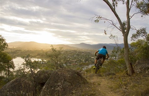
Tyrolean/ Mill Creek Trail Network
The Tyrolean trails are located on Council reserve near Tyrolean Village. The network links to the Jindabyne shared trail and caters to all mountain bike ability levels. The stacked trail loops are a mix of hand-cut single and machine cut tracks.
Council commissioned a review of the trail network through the development of a concept plan and assessment of environmental and cultural heritage values. This project will see further extensions and improvement to the network and associated facilities. Further information on the project can be found here.
Both Jindabyne shared trail and the Tyrolean trail network are cared for by a group of hard working volunteers. The Jindabyne Trail Stewardship are a not for profit group which formed to ensure the trail network is championed, adequately maintained and improved on. For further information on how to support or donate to trail maintenance go to https://www.jindabynetrailstewardship.org.au/
Mount Gladstone
The Mount Gladstone Lookout and Nature Reserve sits in 125 hectares of native bushland less than four kilometres from the edge of Cooma township and offers magnificent views across the Snowy Monaro Plains and to the peaks of the Snowy Mountains from the two easily accessible viewing platforms.
The Mt Gladstone Nature Reserve is also a popular spot Mountain Biking. Click here for a map. The trail network includes loops for all Mountain bike ability levels. Volunteers from the Snowy Mountain MTB Club help care for and maintain the trail network. To find out the latest on trial volunteers days, events and activities go to https://www.facebook.com/groups/snowymountainsmtbclub/
There are walking trails, toilets and barbecue facilities available, along with car and coach parking.
Snowy Monaro Regional Trails Master Plan
Council have developed a Regional Trail Master Plan. The strategy was adopted in June 2022 and includes a review of trails for walking, trail running, mountain bike riding, road cycling and horse riding. The Regional Trails Master Plan Identifies sustainable trail opportunities on Council land which have the greatest potential to create benefits for the community, economy and environment.
The Master Plan aims are to:
- Create a positive & collaborative culture for all users
- Strengthen the perception of the Snowy Mountains region as a destination of choice for mountain biking, cycling, trail running and walking
- Determine the optimal visitor trail experiences & iconic tourism opportunities
- Increase visitation that contributes positively to the local economy
- Enhance the sustainability & livability for local communities.
The Master Plan can be downloaded below.
Snowy Monaro Regional Trails Master Plan